| Restoration site |
Summary |
Images/Maps |
| Jamito 1 Demonstration Farm
View on Google Maps
|
The Jamito 1 Demonstration Farm located in Sitio Mapawa, Songco, Lantapan Bukidnon. It is a 17.5 ha land. It is located at 8°3'24.8"N and 124°56'16.26"E
Read restoration plan in detail
|
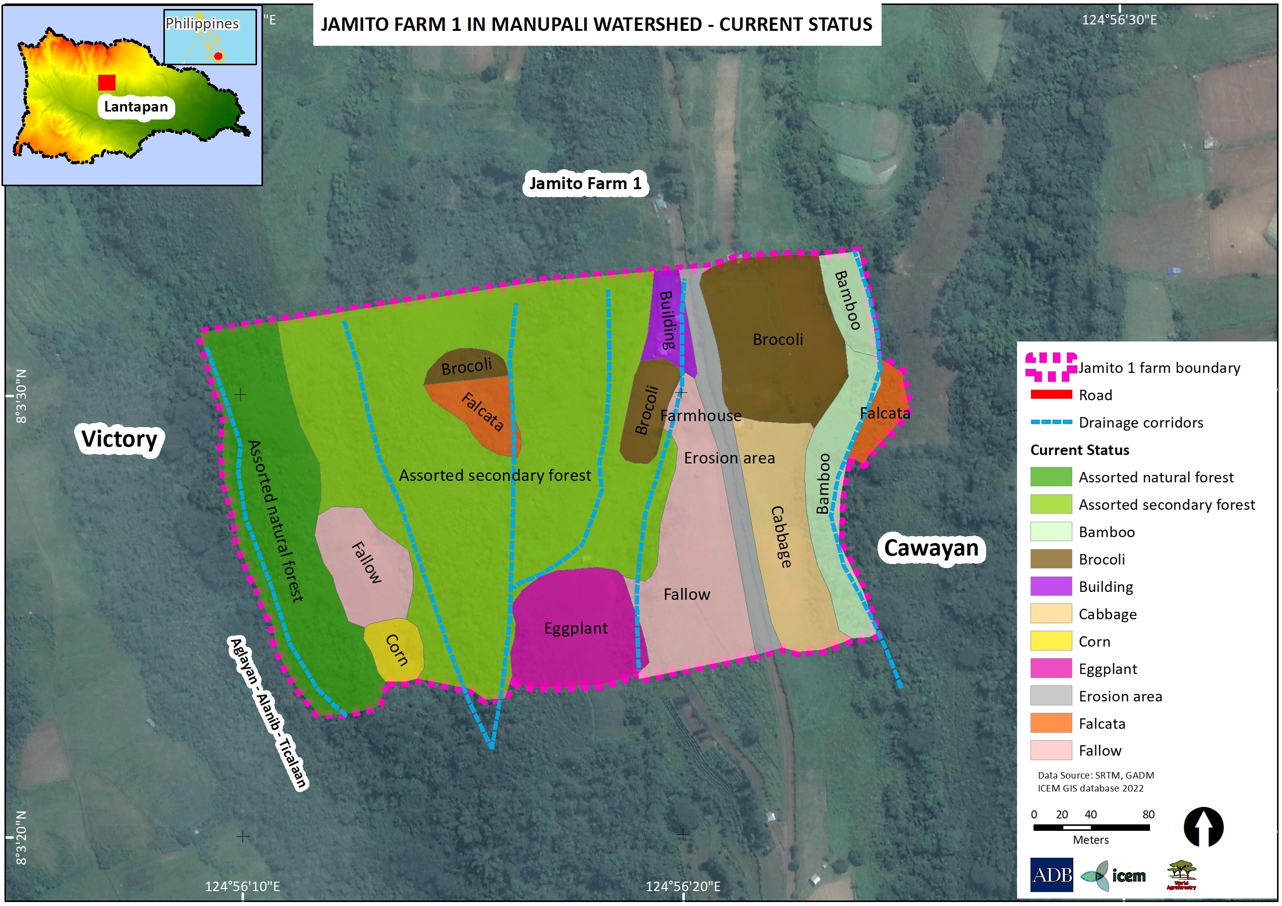
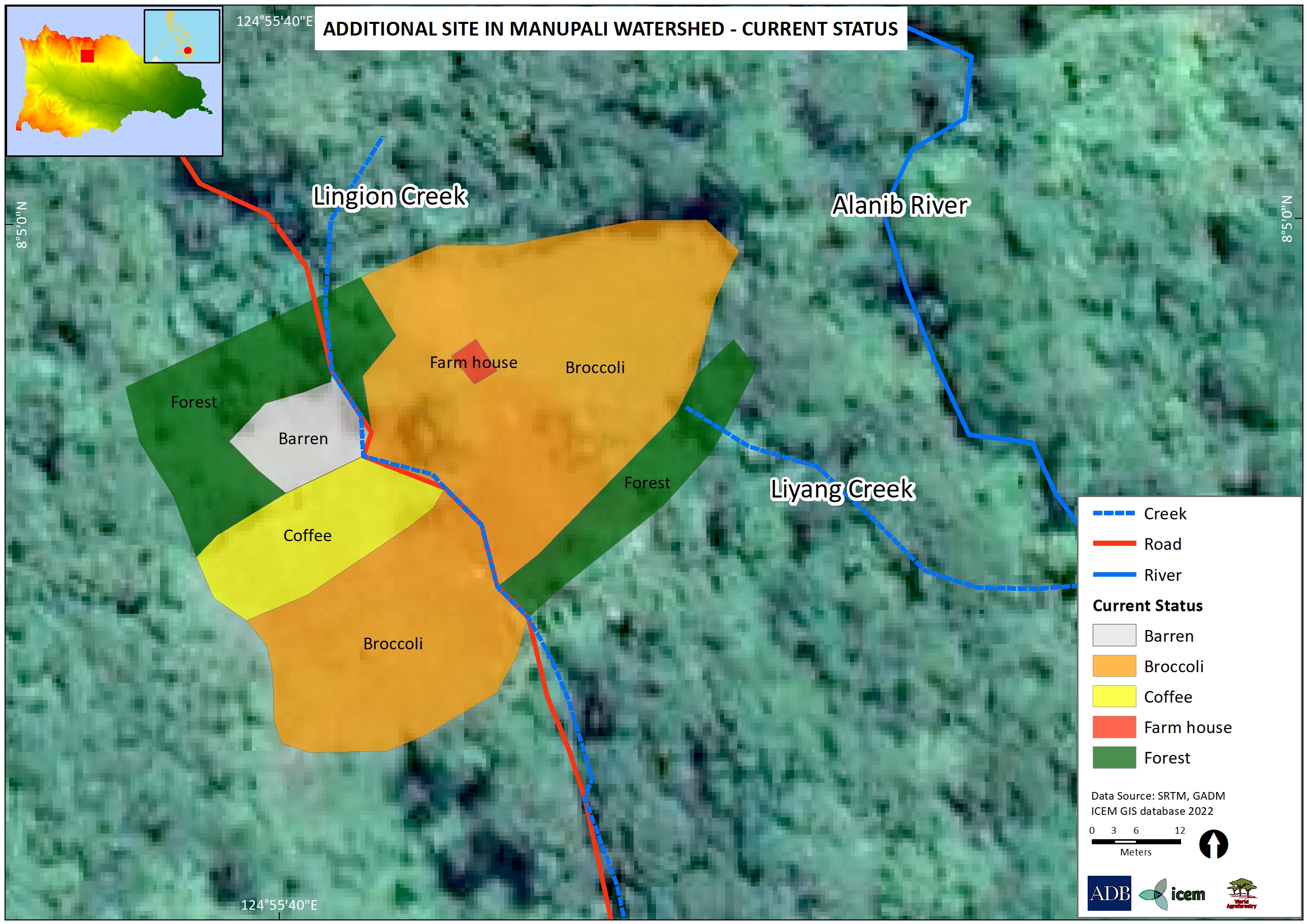
Current land use status of the Jamito 1 Farm based on the July 29, 2022 workshop.
Disclaimer: The boundaries, colors, denominations, and any other information shown on this map do not imply, on the part of the Asian Development Bank, any judgment on the legal status of any territory, or any endorsement or acceptance of such boundaries, colors, denominations, or information.
|
| Jamito 2 Demontration Farm
View on Google Maps
|
The Jamito 2 Demonstration Farm is located in Sitio Cawayan, Songco, Lantapan Bukidnon, and covers approximately 12 ha. Its location is 8°2’45.85N and 124°56’28.48E, and at an elevation of approximately 1,123 m. The site is 390 m from the Aglayan-Alanib-Ticalaan Road.
Read restoration plan in detail
|
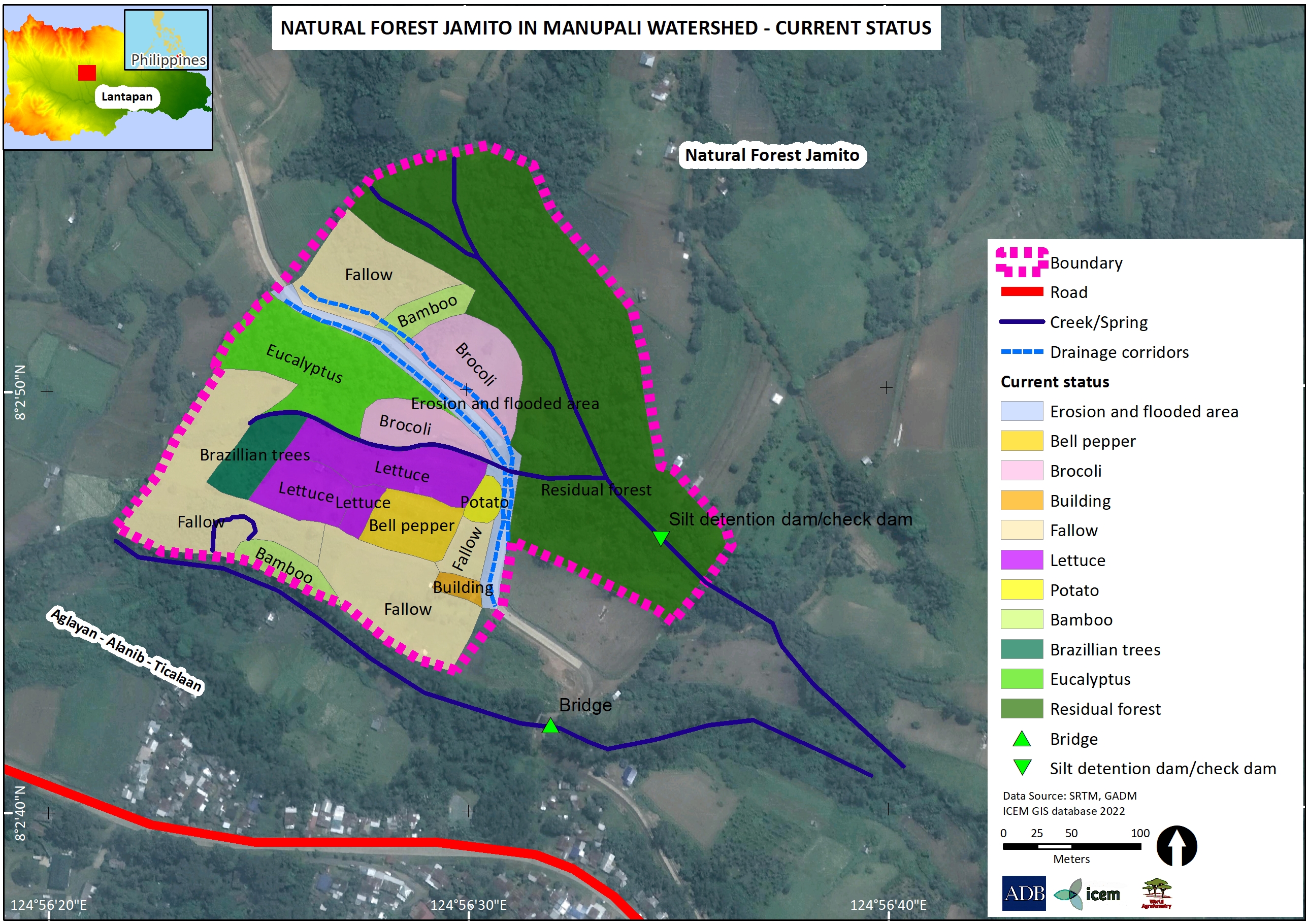
The proposed land use change in the Jamito 2 Demo Farm based on the participatory mapping exercise last July 29, 2022.
Disclaimer: The boundaries, colors, denominations, and any other information shown on this map do not imply, on the part of the Asian Development Bank, any judgment on the legal status of any territory, or any endorsement or acceptance of such boundaries, colors, denominations, or information.
|
| Ladera Demonstration Farm
View on Google Maps
|
The demonstration farm of Martino Ladera, Jr. is located at Sitio Bol-ogan Songco, Lantapan, Bukidnon (8.066040°N, 124.928535°E; elevation of 1462 m). It is approximately 0.66 km from the village center of Sitio Bol-ogan, along the old logging road to Mt. Kitanglad Range Natural Park (MKRNP) and covers approximately 1.2 ha.
Read restoration plan in detail
|
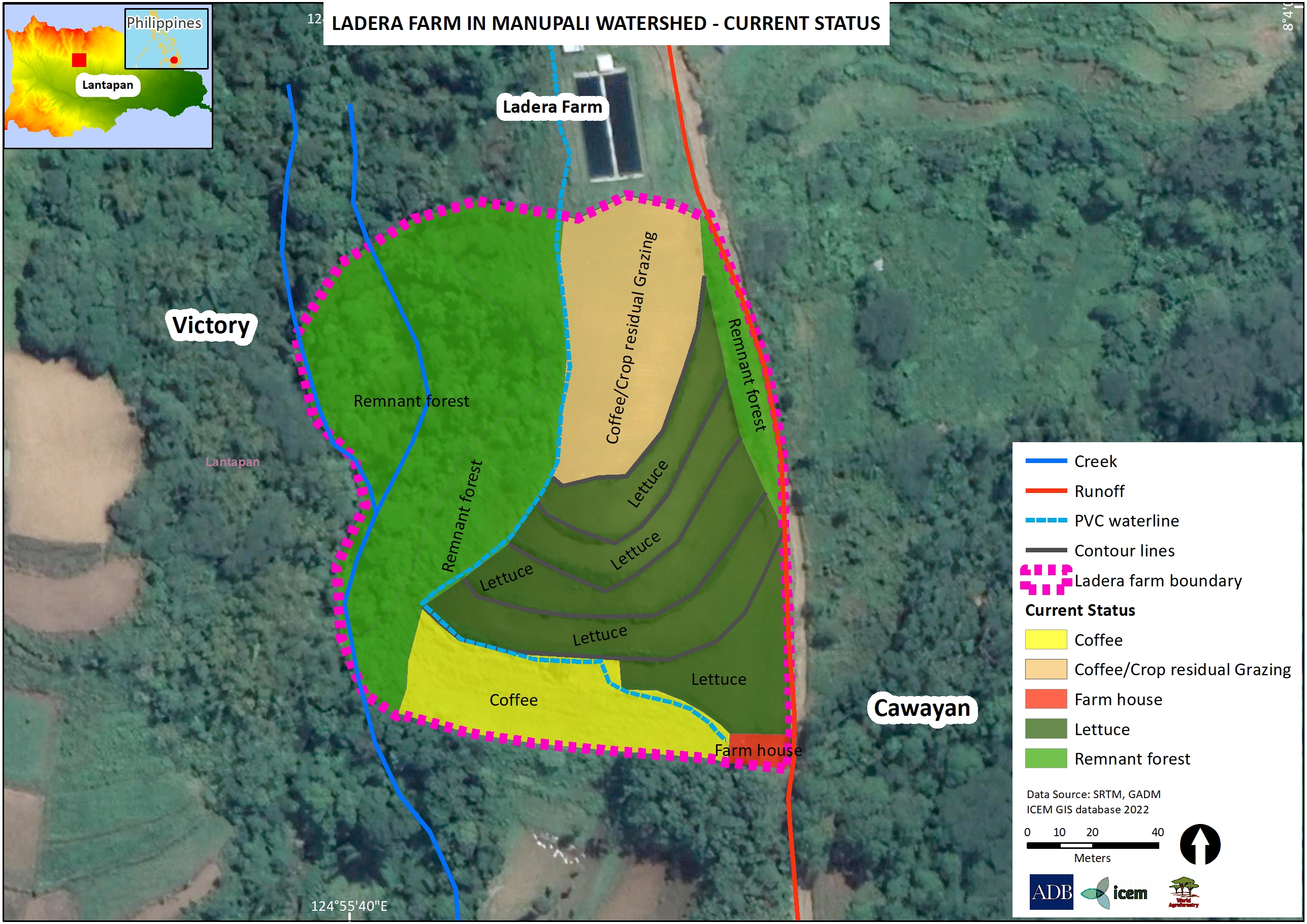
The proposed land use change in the Jamito 2 Demo Farm based on the participatory mapping exercise last July 29, 2022.
Disclaimer: The boundaries, colors, denominations, and any other information shown on this map do not imply, on the part of the Asian Development Bank, any judgment on the legal status of any territory, or any endorsement or acceptance of such boundaries, colors, denominations, or information.
|
| Buffer Zone (Yam-oc) Demonstration Farm
View on Google Maps
|
The demonstration farm is designated as Buffer Zone (Yam-oc) in Songco, Lantapan, Bukidnon and covers an estimated 1.5 hectares. It is located at 8.079058°N, 124.928546°E, and at an elevation of 1,748 MASL.
Read restoration plan in detail
|
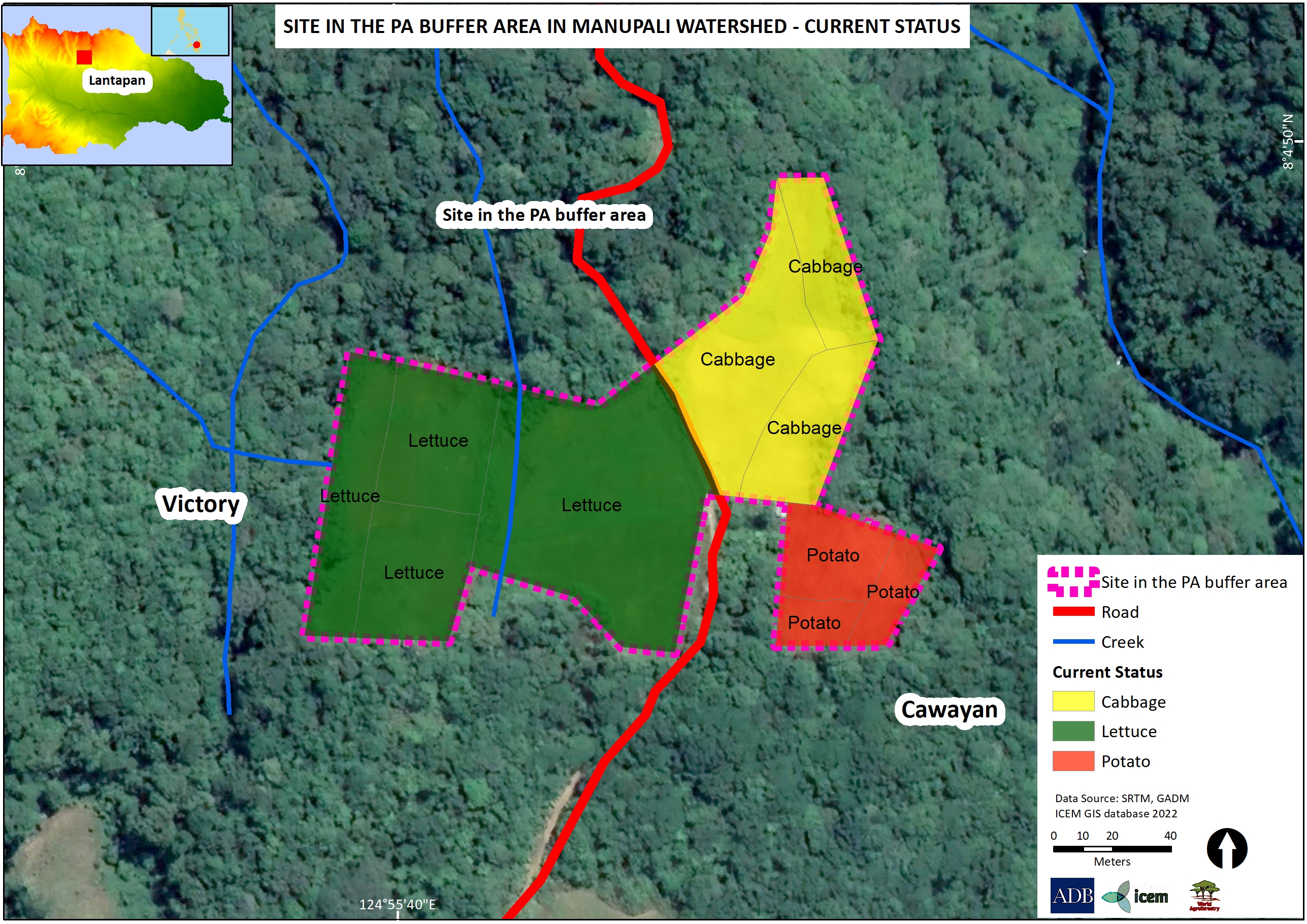
The current land use status of the demonstration site in the Buffer Zone (Yam-oc) in MKRMNP based on the participatory mapping exercise last July 2022.
Disclaimer: The boundaries, colors, denominations, and any other information shown on this map do not imply, on the part of the Asian Development Bank, any judgment on the legal status of any territory, or any endorsement or acceptance of such boundaries, colors, denominations, or information.
|
| Buffer Zone (Valdueza) Demonstration Farm
View on Google Maps
|
The demonstration farm is designated as Buffer Zone (Valdueza) in Songco, Lantapan, Bukidnon, and located in the buffer zone of the Mt. Kitanglad Range Natural Park (MKRNP). Its location is 8.083155°N, 124.927952°E, and at an elevation of 1,836 MASL.
Read restoration plan in detail
|
The current land use status of the Valdueza Farm inside the MKRNP as of July 2022.
Disclaimer: The boundaries, colors, denominations, and any other information shown on this map do not imply, on the part of the Asian Development Bank, any judgment on the legal status of any territory, or any endorsement or acceptance of such boundaries, colors, denominations, or information.
|